Your shoreline field guide
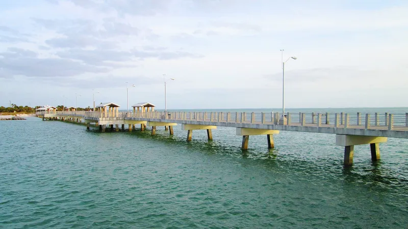
Fort De Soto Gulf Pier
Pinellas · pier
Open7 a.m. to sunset, 7 days a weekPaid: County beach parking fee $6 per day through November 30, 2026 (pay stations, mobile apps, pay-by-text, or annual pass); $3.50/hour capped at $12/day beginning December 1, 2026.
Good for
Target species
Style
piersurfdeep channel
Officially listed features
bait shop on siterestrooms
From the official source linked below.
General guidance: Pier reaches into the Gulf near the mouth of Tampa Bay, so mackerel and pompano schools run past it on strong moving tides in spring and fall.
Wind & weather
Forecast from National Weather Service, updated Oct 25, 7:36 PM ET
Get Tampa Bay access, tides and red tide in your free Friday Shore Report.
We only use your email for the newsletter. Privacy policy.
Conditions can change; check the official source before you go.
| Status | Open |
|---|---|
| Status note | County park page lists Gulf and Bay pier hours of 7 a.m. to sunset; Gulf pier has a food and bait concession. Seawall/sidewalk repairs next to the Gulf Pier are scheduled for construction in spring 2027. |
| Address | 3500 Pinellas Bayway South, Tierra Verde, FL 33715 (park address) |
| Hours | 7 a.m. to sunset, 7 days a week |
| Parking / fees | Paid: County beach parking fee $6 per day through November 30, 2026 (pay stations, mobile apps, pay-by-text, or annual pass); $3.50/hour capped at $12/day beginning December 1, 2026. |
| Amenities | Restrooms, Food and bait concession |
| Fishing license | County states a fishing license is required throughout the park, including fishing piers. Fishing license: who needs one |
Last checked Oct 2026 from Pinellas County: Fort De Soto Park
Fish to target here
General habitat guidance; confirm access and regulations before fishing.
- Snook Gulf and pass water near the bay mouth suits summer snook presentations along current seams.
- Spanish mackerel Gulf-facing access near Egmont channel places small baitfish imitations in coastal migration water.
- Florida pompano The Gulf-facing sand and nearby passes suit bottom crustacean baits and short pompano-jig hops.
- Flounder Sand near the bay mouth and Egmont channel suits slow minnow presentations near pass water.
- Cobia Gulf-facing water near Egmont channel offers a migration corridor to scan with a bucktail ready.
- Whiting Gulf-facing sand suits short bottom casts with tiny shrimp pieces for whiting.
Tide chart, next 48 hours
7-day high/low table
Station: Mullet Key Channel (Skyway) (8726364) · 1.2 km away. Heights in feet above MLLW; station local time (EST/EDT). Predictions are not observed conditions.
| Date / time | Tide | Feet |
|---|---|---|
| 2026-10-26 06:51 | Low | -0.482 |
| 2026-10-26 13:54 | High | 1.59 |
| 2026-10-26 18:02 | Low | 1.039 |
| 2026-10-27 00:02 | High | 2.397 |
| 2026-10-27 07:38 | Low | -0.618 |
| 2026-10-27 14:50 | High | 1.458 |
| 2026-10-27 18:21 | Low | 1.109 |
| 2026-10-28 00:33 | High | 2.526 |
| 2026-10-28 08:29 | Low | -0.64 |
| 2026-10-28 15:51 | High | 1.31 |
| 2026-10-28 18:39 | Low | 1.136 |
| 2026-10-29 01:11 | High | 2.569 |
| 2026-10-29 09:25 | Low | -0.556 |
| 2026-10-30 01:55 | High | 2.507 |
| 2026-10-30 10:27 | Low | -0.394 |
| 2026-10-31 02:49 | High | 2.34 |
| 2026-10-31 11:37 | Low | -0.198 |
| 2026-11-01 03:03 | High | 2.094 |
| 2026-11-01 11:49 | Low | -0.004 |
Red tide (FWC samples, last 8 days)
Nearest sample: Mullet Key; Gulf Pier, Oct 19 2026; not present/background (0-1,000); 0.1 km away. Maximum within 15 km: not present/background (0-1,000) (6 samples).
Samples are point-in-time observations; missing samples do not establish safe conditions. Check FWC’s current report.
Sources
OpenClosedCall ahead
Map requires an internet connection. Spot details are listed below.
Spot a change? Email hello@shorereadytampa.com
Get the Friday Shore Report
Which Tampa Bay piers and shore spots are open, plus tides and red tide, every Friday. Free.
We only use your email for the newsletter. Privacy policy.
No spam. Unsubscribe anytime.